On May 21, 2022 there will be a Chuckwagon dinner hosted at the historic Charles Goodnightbarn located near the Pueblo State Park Southern Reservoir entrance; 5475 W. State Hwy 96, Pueblo.
Restoration has been recently completed on this beautiful sand stone barn after years of work. The grounds were originally going to be open on Friday, but one may want to call the Pueblo Heritage Museum to confirm.
I the grounds will be open on Friday after 2:00 PM. The Chuckwagons should be rolling in around then, but some may be later. You can purchase tickets online or go to Pueblo Heritage Museum at 201 West B Street, Pueblo, CO anytime Tue – Sat, 10AM – 4PM to purchase tickets.
Contact: Gabriella J. March PH: 719-220-0000 e-mail: gjmarch@pm.me
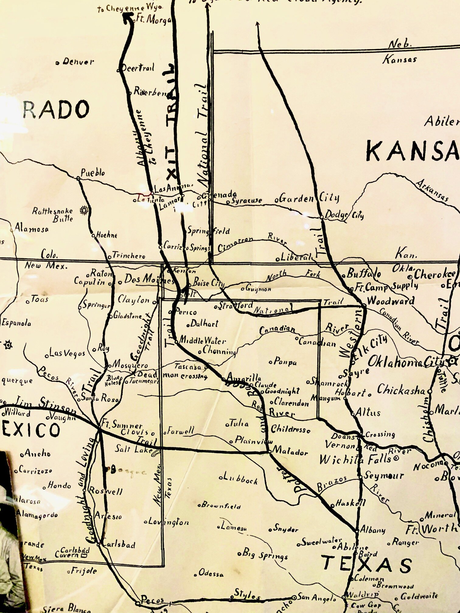
The New Goodnight Loving Trail
In 1874 or 1875 Charles Goodnight was well into his career at driving cattle. His previous trail came into Colorado up along the front range. However, with pressure from front range development and farming, cattle trails were getting pushed farther east. Goodnight changed the northern end of his trail to come into Colorado farther east up Carrizo Creek from the Cimmaron River.
“It left Alamagordo Creek north of the Old Ft Summner, and followed the Goodnight Trail of 1868 to Cuervo Creek, turned east by Laguna and then crossed the Canadian River about ten miles below Ft. Bascom. The trail continued up Ute Creek, passed on the east side of Rabbit Ears Mountain near present day Clayton, New Mexico, and onto the Cimmaron Seco (dry) near Robbers Roost. It then turned up Carrizo Creek, which went slightly north and west to Freez Out Creek and onto Two Buttes Creek and from there on to the town of Granada which followed the recently abandoned Granada-Ft Union military road which was a branch of the Santa Fe Trail.”
From “The Western Cattle Trail 1874-1897 It’s Rise, Collapse and Revival” by Gary and Margaret Kraisinger.
When the trail hits the dry Cimmaron, or the “Cimmaron Seco” as referred to in the book, it heads north up Carrizo Creek canyon traveling right by Robbers Roost (broken up by the army in 1867). Robbers Roost is just east of the eastern point of Black Mesa north of Kenton, OK. This Carrizo Creek canyon runs north all the way up into Colorado and up past Carrizo Springs (located on the Sikes Ranch State Wildlife Area) and north to Freeze Out Canyon (north west of Pritchett). This means that this trail literally went through our back yard as we sit right on Carrizo Creek in Carrizo Canyon just south of Carrizo Springs townsite. SO COOL! I love it when history literally bowls you over.
Traveling this route the cattle would hit water holes at least once a day for the most part in a relatively dry part of the world. That was a pretty big deal. The trail passed through iconic western landscapes and near several infamous historical sites such as Robbers Roost home of the Coe Gang from 1864-1867, Santa Fe Trail, Native American camps, and little known and short lived rough frontier towns like Carrizo Springs. However, for the most part, the trail moved through more remote areas to accommodate the grazing cattle.
At that time really the only people living in this part of the world were trappers, traders, Native American Indians, Mexican sheep herders, and outlaws. Since water was so scarce on the high plains south of the Arkansas River, most of history passed along similar routes following the water sources, game, grass and old trails for travel. Other trails following similar routes include the Penrose Trail, Granada-Ft Union military wagon road, dry cimmaron route of the Santa Fe Trail.
Experience It
You can walk along this route at Carrizo Canyon Campground and the Sikes Ranch State Wildlife Area in southwest Baca County, CO.