Springfield/Campo, CO
Hike & Location Information
Total Mileage/Elevation: 4
Location: 8 miles west of Campo, CO
This Trail is Good for: Hiking, trail running, horseback riding, birding
Dispersed Camping Nearby: Camping at the parking lot area
Forest Service Campground Nearby: None nearby
Pets: yes, on leash with people around or under control
Duration of Hike: 3-4 hours
Possible Loops: yes, you can connect this hike with the longer Homestead and Outlaw Trails. The Arch Rock trail is a loop as well.
Time of Year I Hiked the Trail: early April
Time to Nearest Town: Campo is 30 minutes away and Springfield is 45 minutes away.
Condition of Approach Roads: Well maintained gravel roads.
Directions to the Trailhead
In the town of Campo turn west at the Campo Café building on the main street (Hwy 287). Cross the railroad tracks and drive 8 miles west on CR J. At CR 18 turn south and follow CR 18 until you see the Forest Service Sign for Picture Canyon on the south side of the road. The road will be curving to the east as you see the sign for Picture Canyon. Turn south onto this road and go 2 miles to the parking area.
Trail Description:
The Arch Rock Trail begins at the Picture Canyon parking area and you can either go north counter clock wise around the loop or south and clockwise. I typically go south as I feel like the trail is easier to follow from this direction.
The trail begins by going south along an old two track road into Picture Canyon proper. There are several petroglyph panels in this canyon that are worth checking out. There is also a big seep spring that is great for birding.
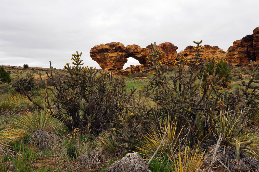
The trail bends back to the north and west after about .75 miles and leaves Picture Canyon through a smaller canyon arm that mostly travels west and a bit north. The trail then goes up through an out crop of small hoodoo rocks and works its way up to the top of the rim. Following this rim to the west, the trail goes across the top and catches the top of the next drainage that goes west and slightly south. The trail is fairly vague in this area, so look for the posts and markers along the way. When you get to the two track road on top that runs north and south, you will go slightly north to the next marker, that is hard to see as it is mostly fallen down. This small drainage takes you to the Arch Rock Formation area. At the mouth of this small little canyon, you can look to the north and Arch Rock is the end of the arm of rock stretching out to the north on the east side.
You can either hike up to Arch Rock and continue around the loop in a clockwise direction or return back the way you came. If you were to continue on to the Homestead trail you would continue down the drainage instead of hiking north up to Arch Rock.
After Arch rock the trail gets a bit harder to follow in places. The trail goes east and slightly north and circles back to the main parking area. If you end up loosing the trail (which happens to me regularly) you can always follow the two track road from Arch Rock to the north where it intersects another two track road that runs east and west. Here you go back to the east to the parking area.
However, if you persevere and are diligent about looking for the trail, the trail heads across some flats, past an old homestead ruin, and either down a draw and back to Picture Canyon, or across the top and you make your way down the rim rock to the road and back to the parking area. Basically just head east. You will eventually pop out either in Picture Canyon or on a road!
Where to Get Maps for This Hike:
Tubb Springs Product Number 49426
Campo SW CO Product Number 47772
CalTopo Online Mapping Software- https://caltopo.com/map.html
Forest Service Contact Information
Picture Canyon
Comanche National Grassland office in La Junta: (719) 384-2181 or in Springfield: (719) 523-6591.