Total Mileage: 7.2 Miles (We only went to the Trail intersection – TO BE CONTINUED)
Hiking – Total of 3.59 to North Brush Trail Intersection from Ducket Creek Trailhead on RD 337. 1 mile on Rainbow Trail to Rd 337, .36 miles to Rd 331, 1.3 miles to RD 331 parking area. Then .93 miles on the Peerless Trail to North Brush Trail intersection.
Driving – 2.5 continue on 337 to 331 to the parking area up a narrow winding 4WD road. The road was in good shape, but would require some clearance and 4WD in wet weather. There were normal SUV’s up there pickup is not required. Then .93 miles on the Peerless Trail to the North Brush Trail intersection.
Location: North of Westcliffe 13 miles take RD 198 west to 337 and the Ducket Creek Trailhead. Straight west of Hillside, CO.
This Trail is Good for: Hiking, 4WD driving, fishing, day hiking, backpacking
Dispersed Camping Nearby: Yes, lots along RD 337 driving up to the Ducket Creek Trailhead and some past the trailhead as well for smaller vehicles (no RV’s). You can get RV trailers and pickup campers in on RD 337 up to the Ducket Creek Trailhead. There is also dispersed camping up 198, although this road is very rough and requires high clearance vehicles past the Lake Creek Campground.
Forest Service Campground Nearby: There is a Forest Service Campground along 198 called the Lake Creek Campground with pit toilets, tables etc. Within 1.5 miles of Ducket Creek Trailhead.
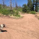
Pets: Yes, under control but not necessarily on a leash (unless needed)
Duration of Hike: 7-9 hours round trip to the lakes depending on starting point and how far you go.
No: Bikes or motorized vehicles, this is in the Sangre de Cristo Wilderness Area
Possible Loops: With South Brush Trail via the Cross Over Trail by South Branch Lake, Banjo Lake and Electric Peak. The Cross Over Trail is not a maintained trail! These North Brush Trail also Crosses over the mountains to become the Major Creek Trail on the west side of the Sangres.
Time of Year I Hiked the Trail: We hiked in mid June (June 10) on a low snow year and we saw no snow at all.
Directions to the Trailhead
Take Hwy 69 to Hillside, directly on the south side of town is RD 198. There are signs there for forest access as well. Take this road approx. 4 miles W. At an intersection you can go right to the Lake Creek Campground on 198 or left to RD 337 and the Ducket Creek Trailhead. Approx. .3 miles up 337 you turn right again through a gate to stay on 337 to the Ducket Creek Trailhead.
Time to Nearest Town: 10-20 minutes. Hillside, CO is 4 miles from the Ducket Creek Trailhead. Westcliffe is 13 miles south of Hillside. Texas Creek is 13 miles north of Hillside, CO on Hwy 50 between Canyon City and Salida.
Condition of Approach Roads: The 4 miles in on 198 is a very well maintained gravel road. The 337 is also very well maintained although narrower. You can get RV’s into the dispersed camping along 337 at least to the Ducket Creek Trailhead; it gets narrower and steeper after that.
Trail Description
This was an exploratory hike since I had not hiked in this area much before! I couldn’t find a whole lot of trail beta online before I went so we kind of went at it just following the maps and walking due to unknown road conditions.
We camped at a dispersed campsite .1mi from the Ducket Creek Trailhead on the Rainbow Trail. I was able to get my large pickup camper into this location just fine. Horse trailers are pulled up here frequently. There were fire rings, but we were under a fire ban when we visited so used stoves in our campers.
Our plan was to hike up North Brush Creek Trail from the Rainbow Trail as far as we wanted to in a day. It’s a long hike so we weren’t sure how far we’d want to go being new to the trail. We started the morning at Ducket Creek Trail Head

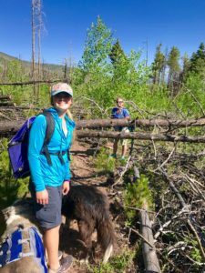
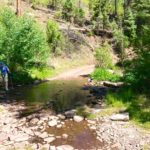
and hiking south along the Rainbow trail for 1.72 miles through a burn area. Several creeks washed across the trail as we went which was great for the dogs. They had plenty of water opportunities.
When we got to the North Brush Creek Trail there was a nice large campsite at the trailhead.
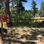
You can tell hunters and large parties use it extensively at certain times of the year. And can I please put a Leave No Trace plug in here!! Please pack out your used toilet paper. No one wants to see that in our backcountry. Even if you bury it – it seems to surface one way or another. Rant over!
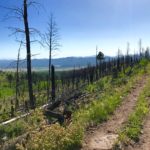
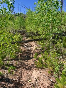
As we started up the North Brush Trail we quickly discovered that the fire that had swept through the area left lots of dead trees, which have blown down and pretty much destroyed the trail. We hiked in ¼ miles and then turned around. It was gonna be pretty miserable trying to go this way. The trail has not been maintained much as far as we could tell.
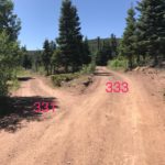
But after looking at the maps we decided to try and head up RD 331 to another trail that intersects the North Brush Trail farther up the valley to the west. We walked back to the Rainbow trail and then back towards the Ducket Creek Trailhead to where RD 337 intersects the Rainbow Trail. RD 337 goes west (up) to meet up with RD 331. We followed RD 337 .36 miles off the Rainbow Trail to the west (up) to intersection with RD 331. We continued to follow RD 331 at an intersection with RD 333. You take the left fork here.
The road winds up the mountainside steadily as Ducket Creek Trailhead is around 8,300/8,400 ft. and the Peerless Trailhead is at 9500ft. There are a couple of small creek crossings along this road too for water refills or doggie dips. It is an exposed and mostly shade-less hike up since the trees for most of the road are in the burn area.
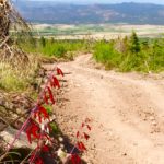
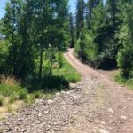
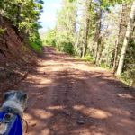
Towards the top of the road you re-enter the forest that has not burned again. About .2mi from the parking area there is another road that takes off from 331 but you want to keep going to the left and not take the other road. There was no road sign that we could find here at this intersection. At the parking area for the Peerless Trailhead there is a creek that crosses as you enter it and an old cabin in the parking area. This road is in good condition if narrow and SUV’s were easily able to make the drive to this trailhead.

The Peerless Trail takes off directly across from the creek crossing on the left side of the cabin. Do not try to go up the creek. The initial1/4-1/2 miles up the Peerless Trail is RIDICULOUSLY steep and very rocky.

.75 miles up the Peerless Trail you have gained 800 feet to 10,300ft and are on the top of the ridge where there is a camping area and a good view up the North Brush Creek Valley to the east and west.

You then drop 100 feet steeply into the valley and find the North Brush Trail intersection .16 miles past the ridge. The trail at this point is well maintained and is a nice trail although it will continue to gain in elevation to over 11,000ft at the lakes. We hiked up the trail a little over a mile to where the trail comes very close to the creek and there is a camping area. We stopped here and had lunch and rested before we turned around for the day. We wasted a couple of hours hiking time finding the correct trail head, and ran out of time to continue on. We left from here at 2:43pm and were back at our camp at Ducket Creek by 4:00pm. The distance from our lunch spot to our camp at Ducket Creek was 3.59 miles and 2,000 ft. down.
Next time I will drive to the Peerless Trailhead cutting out the road walk from Ducket Creek. It is a narrow road with some steep drop offs on the side, but not super rough. Until next time and the rest of the way to the North Brush Creek Lakes!