Total Mileage: My GPS showed 5.9 miles for the loop
Location: Palmer Trail also called the Red Rocks Loop Trail at Section 16
This Trail is Good for: Mountain biking, hiking, trail running, access to Red Rocks Open Space from the south and very west.
Pets: Yes, should probably be on a leash as there are a lot of people around most of the time. Bring baggies to pack out your pets poop.
Duration of Hike: 3-4 hours depending on pace. I was really sucking air on the way up due to a recent cold and still finished the hike in 2:45.
No: n/a
Possible Loops: There are LOTS of possibilities here as there are many trails in Red Rocks Open Space. Check out their maps for other options. This trail also follows the Ring the Peak Trail for awhile which is a collection of trails and roads that encircle the base of Pikes Peak.
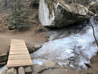
Time of Year I Hiked the Trail: Jan 3, 2018. The conditions on this trail I believe are not usually as clear this time of year, but this year has been very dry with little to no snow and the trail was completely clear of snow and ice. Check ahead for winter trail conditions microspikes might be recommended!
Directions to the Trailhead
Take Hwy 24 west at the Cimmaron Exit off of I-25 in Colorado Springs to 26th Street. At 26th take a left or (south) and follow it until you come to a four way stop with Bear Creek Rd. You will wind up a bluff before you get here. At this stop sigh take a right onto Gold Camp Rd and continue slowly, as the road gets fairly narrow for two vehicles passing, up the road about 1.5 miles to the pull off for parking at Section 16 Trail head. There is a large 3 panel sign and a Sign Stating Section 16 with a set of stairs leading up off the road. The parking area is not very big, but if it is full pull past it about 75 yards to another parking area on the other side of the road just out of sight. Just down the hill there is another parking area where Bear Creek Road and Gold Camp Road meet again on both sides of the intersection.
Time to Nearest Town: 5-10 minutes you can be back in Old Colorado City or to Hwy 24. You are on the very edge of town with housing developments all around.
Condition of Approach Roads: The roads are all paved although could be a bit slick on the curves and steeper parts of it is icy or snowy. I imagine they are well maintained being pretty much in the city and receiving high use.
Trail Description
I have a guide book of front range hikes and since I was in Colorado Springs for the week I decided I should take advantage of it and try out some of the ones it suggests around the city. This hike is what this guide book says is, “one of the best hikes near Colorado Springs*.”
I did the hike in reverse order from what the guidebook suggested and am actually glad I did as I ended up climbing the steepest rockiest part and descending on the nice graded trail. Which in my opinion was a much nicer way to do it. Going down steep rocky trail with loose rock is not easy on knees or easy to keep upright in general. Also, not being familiar with the hike starting from the parking area at Section 16 and after studying the map there on the kiosk I had a better idea of the trails I needed to take to get to the Palmer Trail, and I very well might have become confused trying to get back to my car coming from the south (opposite way I went) with all the options of trails that there are on the northern part of this loop in Red Rocks Open Space. As it was I was able to follow the signs they had for the Palmer/Red Rocks Loop up the norther side of the loop in Red Rocks Open Space to the ridge and then the trail options decreased significantly once you crossed over into the Pike National Forest and the Bear Creek Canyon Park. So long story short it turned out for the best and I would recommend hiking the trail in the counter-clockwise direction (North side of the loop to the south side).
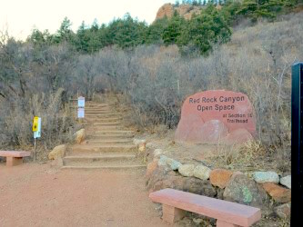
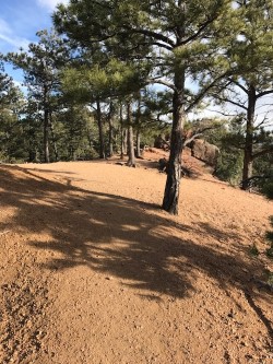
Starting at Section 16 you head straight up a set of stairs and continue climbing….Your starting elevation is somewhere around 6,300 and you will climb to right at 8,000 so just settle in at a nice easy pace. The first part of the trail winds up through oak brush breaking into the ponderosas and pines as you climb a bit. You will climb up a ridge passing several trails that go off to the north and come to an intersection where several trails take off at a rocky outcropping and some Ponderosas. You will go left here and continue climbing on the Parallel trail or stay on the Red Rocks Loop Trail either way will get you there. Continue climbing and the trail gets steeper and rockier .75-1 mile in. for about the next mile you will climb fairly steeply up to gain the ridge at 8,000 feet. The trail winds through the forest which is all pine and being on the north side of the ridge was in the shade most of the time at 2pm in the afternoon during the winter.
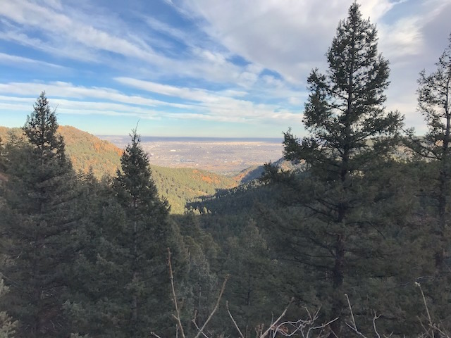
Once you gain the ridge, approx 1.8miles in, you can look off into drainages on both sides for a short time as you hike along the ridge winding around the Bear Creek Canyon Park on the west end.
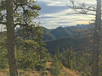
The trail becomes a much more gradual grade and is much less rocky for the remainder of the hike heading steadily down as you hike south and then turn back to the east after you cross Hunters Run Creek (approx mile 3).

It is a pleasant wooded hike with occasional views of the city off to the east and the drainage below you. From Hunters Run Creek you have approx 2.8 miles back to the parking area.
The trail winds down the south side of the drainage you are hiking above loosing elevation until you finally come back down to the road (Approx mile 4.8)

From here you turn left (north) and hike back up the road to a gate, past an old house to an intersection of Gold Camp Rd and Bear Creek Rd. Hike a short .1-.2 mile up Gold Camp Road (left or mostly straight) to the parking area which is just out of sight over the hill from this intersection.

The hike is a nice hike especially if you want a bit of a workout but it has a nice balance of up and down with some nice views. If you end up hiking the trail from south to north, just be aware that there are a lot of intersecting trails in Red Rocks Open Space and it could be confusing to find the parking area if you are not familiar with the area. But you would probably have great views coming off the ridge looking north as well. Enjoy! This was a great hike especially for being so close to a major city.
*Bob D’Antonio, Hiking Colorado’s Front Range,”Section 16/Palmer Trail, pg 199-201″, Guilford, CT, 2012